Rain and mountain snow to make pre-Thanksgiving travel difficult in Colorado
GRAND JUNCTION, Colo. (KJCT) - Holiday travel in and out of Colorado may be disrupted by a large storm system that will bring rain and snow.
Sunday Evening Rain & Snow End
Rain and mountain snow this evening is associated with a weak disturbance passing over Colorado. Most of the rain and snow will end locally by 10 PM. Anything lingering will exit by 2 AM, and the clouds will begin clearing so that we start Monday with some sun.
Thanksgiving Day Forecast
Thanksgiving Day may start with lingering clouds, but the sun will come out to brighten the holiday. The high temperature will be near 42 degrees around Grand Junction, 36 degrees around Montrose, and 43 degrees around Cortez. Expect mostly 30s in the mountains and around the Front Range with 40s in the least cold areas.
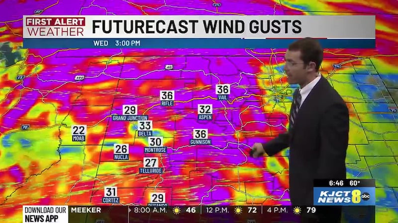
Thanksgiving Travel: Monday through Wednesday
Travel on Monday will be most problematic up and down the West Coast with widespread rain and mountain snow from Seattle to Los Angeles. Another storm system will affect the Upper Midwest and Great Lakes around Minneapolis, Chicago, and Detroit. That system moves to the Northeast on Tuesday, affecting areas like New York Washington, and Boston. Wednesday is still unsettled in Colorado and Utah.
Timing of Rain & Snow
More rain and snow will arrive Monday night through Tuesday. Clouds will start increasing again after about 1 PM ahead of Monday night and Tuesday morning rain and snow. Rain in the valleys and snow in the mountains will increase after midnight Monday night and into Tuesday morning. Valley rain and mountain snow will be with us for much of Tuesday, Tuesday night, and Wednesday morning. There can be some breaks in that time. Rain and snow will start breaking up between 6 AM and noon on Wednesday, but lingering on-and-off snow is possible through the afternoon.
Expected Snowfall Amounts
The heaviest snow will fall in the mountains. We’re not likely to get more than an inch or two - if we get anything at all - in the valleys. The Grand Mesa, the Elk Mountains, and some areas of the San Juans can get more than two feet of snow. Up to 1-2 feet of snow can fall in the central and northern mountains with locally two feet possible.
Our Next 24 Hours
This evening will be cloudy. Occasional light rain is possible in the valleys, and snow will fall over the mountains. We’ll cool slowly from low-to-mid 40s at 6 PM to upper 30s and lower 40s at 10 PM. The rest of tonight will be cloudy. Rain and snow will end by morning. Low temperatures will be near 29 degrees around Grand Junction, 26 degrees around Montrose, 27 degrees around Delta, 22 degrees around Cortez, and 24 degrees around Moab. Monday will be partly cloudy to mostly sunny to start, then clouds will increase after noon and we’ll become mostly cloudy by the evening drive. High temperatures will be near 49 degrees around Grand Junction, 48 degrees around Montrose, 50 degrees around Delta, 50 degrees around Cortez, and 49 degrees around Moab.